Melissa Parsons, Martin Thoms and Richard Norris
Cooperative Research Centre for Freshwater Ecology
University of Canberra
Monitoring River Health Initiative Technical Report Number 22
Environment Australia, 2002
ISSN 1447-1280
ISBN 0 642 54888 9
The reference site selection procedure for the physical assessment module considers humans to be part of the landscape (Norris and Thoms, 1999) and thus, is based on the concept of 'least disturbed' condition. Collection of reference site information is central to the construction of a predictive model and in turn, this information is used as the baseline against which the condition of test sites is assessed (see Part 1). A reference site selection procedure that uses the concept of least disturbed condition essentially allows for the careful inclusion of sites that have inevitably been affected by humans, but which are considered to be the best available representatives within a certain area or of a specific river type.
The reference site selection procedure described here is similar to that used in the AusRivAS program (see Davies, 1994). However, slight modifications have been added to allow for the stratification of reference sites across a range of geomorphological river types. This stratification step ensures that sites from different 'functional zones' are included in the reference site database. Given that local scale habitat features will differ among functional zones (Schumm, 1977), the stratification of reference sites across these zones will ensure representation of the characteristic habitat features that are associated with each zone type. In turn, inclusion of reference sites from different functional zones will strengthen the robustness of predictive models for assessing a range of test sites and human impacts (Reynoldson and Wright, 2000). The existing AusRivAS reference sites will be overlain across the zone types and used wherever possible, although additional reference sites may be required in zone types that are currently under-represented.
In addition, the reference site selection procedure has been designed to accommodate several levels of heterogeneity, as a 'safety-net' for the robust construction of predictive models. The site selection procedure will incorporate a regional stratification element as well as a functional zone stratification element, because it is not known in advance whether groups of reference sites will classify on the basis of State or Territory wide regional patterns or on zone type patterns. Thus, regardless of whether reference sites are grouped on the basis of regional or zone type patterns, enough sites will exist in each group to allow the construction of robust predictive models.
The reference site selection procedure assumes that like AusRivAS, sampling will be conducted by State or Territory agencies and that ultimately, the predictive models will be set up on a State or Territory basis. Thus, the steps described below should be applied in each State or Territory. The following sections also assume a general familiarity with the concept of 'least impaired condition', as used in the National River Health Program and the development of AusRivAS predictive models. The reference site selection procedure consists of six steps:
Each of these steps will be explained in detail in the following sections.
The division of each State or Territory into broad regions allows the stratification of sampling sites across areas with different climatic and geological characteristics.
Within each State or Territory, identify broad climatic regions which have markedly different rainfall and temperature regimes. These broad climatic regions may also have characteristic vegetation patterns. Then, identify broad geological regions. Maps of geological regions can be found on the Australian Geological Survey Organisation's website at http://www.agso.gov.au.
Using primarily the information on broad climatic patterns, and secondarily on geological patterns, delineate a final set of regions that characterise State or Territory wide differences in both factors. The scale of resolution for the final regions should be kept large and broad. For example, a State may contain four major climatic regions, two of which encompass two major geological regions (Figure 2.1). Thus, the State should be divided into six broad climatic and geological regions. The broad climatic and geological regions should be marked onto topographic maps.
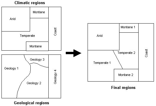
Figure 2.1 Example delineation of broad climatic and geological regions within a hypothetical State or Territory.